
Cactus
This dome is the very focal point of this website and the documentary film to come because it’s now a problem of gargantuan proportions… it’s leaking.
And what’s underneath it is cause for incredible concern.
This project is a plea: do not pass it by, because everyone on the planet will suffer if we ignore this.
The time of the US’s involvement in this sleepy corner of the Pacific is a slow-motion, thousand-car pile-up on a foggy freeway. It may have begun in 1946, but it having widespread repercussions to this day. It’s the awful gift that just won’t stop giving; the carnage will not stop.
I immediately saw in this story a documentary film project that would draw together many elements that mirror my own deeply held beliefs; an ongoing human rights tragedy brought on by US imperialist militarism, massive environmental degradation and the effects of global warming. All this is capped off with the almost unimaginable threat posed by a forgotten remnant of the Cold War. There are also layers of secrecy and disinformation overarching all proceedings, an ongoing effort to ensure this travesty stays forgotten. The truth needed to be hidden by some powerful vested interests. In order to keep it all under wraps, the benign-sounding Pacific Proving Grounds were entirely off limits to outsiders until 1986 – everyone except the original inhabitants, that is. It’ll become apparent why later.
In 1946, with WWII barely over, the US invited itself into the Marshall Islands and, without so much as a by-your-leave, began testing nuclear weapons there. At the outset, in order to mask its deceit, a laughable parody is enacted on film, for public consumption, as evidence to the wider world that the Bikinians are only too happy to surrender their homeland to a devastation they can’t possibly comprehend. They’re fed a shameless fiction about the tests being ‘for the good of all mankind’, with the intention of ending all wars and that they’ll be able to return soon and resume life as though nothing had ever happened. In the pantheon of historic, bald-faced lies this one is close to the worst. If the Bikinians had known anything about the history of white settlers in America, they might have dared the military men to go ahead and blow the atoll up with them on it. What happens afterward is harrowing enough and makes very difficult reading but I’ve tried to lay it out as clearly and truthfully as I can. Where I could, I have used the spoken testimony of the people who lived through it as well as a great deal of declassified documentation from government files. We all owe a huge debt of gratitude to Bill Clinton’s Secretary of Energy, Hazel O’Leary for uncorking thousands of secret files on some of the government’s less palatable programs.
This story, as it stands, is one of heart-rending, unending betrayal; a mountain of broken promises from US authorities lies beneath the surface of the beautiful lagoons here. The literal tidal waves that spread out from the bomb tests between 1946 and 1958 may have dissipated but left unimaginable destruction in their wake, not just huge, gaping wounds to the atolls walls themselves but also deep, festering sores on the psyche of the people; it’s an entire population with PTSD. They can never go back to the atolls, they’re so radioactive. Indeed, the atolls are no longer whole. Some of the islands that formed them no longer exist, just deep, dark water in threatening craters.
As beautiful and bucolic as the atolls were, they proved ideal for the type of weapons testing the US wanted to do, ostensibly because they were so remote and, more importantly, sparsely populated with what were referred to as “happy, amenable savages” in government newsreels of the early 1950’s. They could easily be moved and were, frequently, herded around like so many sheep. The deep racial overtones of this story are hard enough to read. There’s no amount of lipstick you can put on this pig….
Its worth mentioning that the Galapagos Islands were also on the short list of possible sites at one point. The US was fully prepared to vaporize a unique World Heritage site with unparalleled biological diversity in the name of nuclear testing, such was the madness to ensure someone else’s security.
As it was, the tests produced unimaginable physical damage but far more insidious was the slow unraveling of the social and cultural fabric of the Marshallese nation once they had ended. This was a profoundly stigmatized people. The severely deformed fetuses the tests produced were deeply traumatic for a people that had never experienced them before; for a deeply religious people, they seemed demonic. A medical program was established in the 1970’s to study the various cancers, deformities, stunted growth and other ill effects the tests left in their wake. The islanders believe this was one of the primary goals of the tests, to turn them into guinea pigs for study. They were left in a deeply poisoned land and studied for 28 years.
They will tell you, they belong to this land; this is where they come from, yet so crushing is their sadness that many speak of no longer procreating, of inviting their own extinction. This is the true legacy of the Bomb.

On May 5, 1958 the US exploded an 18 kiloton nuclear bomb on Runit, an island of Enewetak Atoll. It dug a crater about 360 ft across and 30 feet deep in the coral wall. In itself, there’s nothing remarkable about this particular test; it was a squib compared to previous tests like Ivy Mike or Castle Bravo, one of many similar small detonations, almost lost in the morass, designed primarily to look at ground effects, the type of damage small weapons would do to metal structures, aircraft, and so on. In the pantheon of all atmospheric testing, both in the Marshalls and in Nevada, it barely registered, just another bomb. These ‘effects’ tests were not looking for raw destructive power but to better examine the actual structural changes on differing targets, post explosion. More refined data could be gained from these smaller tests since they didn’t vaporize everything in sight so there were hundreds of them, all told.
Only much later would this test, code-named Hardtack Cactus, become such a landmark, in a number of definitions of the word, and in the wider landscape of Cold War weapons development. As we will see, only with the vastly changed landscape would Cactus become a problem of such unimaginable proportions and one that will have worldwide implications.
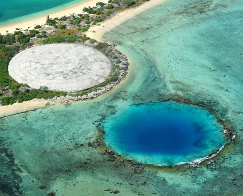 The Cactus dome in the background. In front is the Lacrosse crater, just offshore
Between 1946 and 1958 the US detonated 43 nuclear weapons on Enewetak and another 24 on Bikini atoll. Enewetak is an uneven oblate, roughly 23.5 by 17.5 miles or about the size of Greater Los Angeles. Bikini is smaller, just 23 by 10 miles. These once beautiful atolls rapidly became the most toxic places on Earth. Many of the islands that make up the atolls had a poisonous soup of heavy isotopes like Iodine 131, Strontium 90, Cesium 137 and plutonium 239. Some of them have half-lives lasting just a few decades and eventually dissipate harmlessly into the environment; plutonium 239, on the other hand, lingers on for more than 240,000 years.
Runit Island, just 10,000 ft long and less than 800 ft at it’s widest, was the chosen site for 18 tests, on the surface or in the lagoon very nearby, mounted on barges. Two weapons tests here were fizzles; they exploded sure enough, but not in the way they were designed, never reached criticality. They simply spewed raw, unburnt plutonium 239 over a wide, wide area. This happened a number of times on Bikini as well. Fizzles are far more dangerous, after the event, than a weapon that went off as intended, the effects infinitely longer lasting. This raw plutonium is, in part, what was eventually swept up into the crater. A great deal more ended up on the bottom of the lagoon where it sits to this day. Runit was an extremely hazardous environment by any standards and yet men were working here in little more than shorts, boots, and hats. Let’s not forget about hats; you had to be protected from the Sun. Some of the men have reported to me, in person, that they had no gloves and had to use their bare hands in moving a the kind of highly contaminated material no-one in their right mind would think of handling without a hazmat suit.
Even once the nuclear tests were over the US continued to abuse Enewetak. In a series of tests code-named PACE, high-powered rocket motors for missiles further contaminated the Northern islands of the atoll with beryllium, a category 1 carcinogen. However, in the early 1970’s, a decision was made to try and remediate the atoll and return it to its original inhabitants. When one considers the promises made to the Marshallese people prior to when the testing programs began in 1946, assuring them that they would be able to return to their homelands and of what great benefit the tests would be to all mankind, one can only marvel at the hyperbole. In early 1972 the decision was made to return Enewetak Atoll to the Trust Territory of the Pacific Islands (TTPI) and in as close to its original state as was possible at the time. The US committed itself to the cleanup and rehabilitation of the atoll, among other things. This year also sees the first full-scale radiological survey of all the islands. Only then would it become clear just how bad the situation was. The northern islands, where all of the tests had been conducted were severely contaminated.
In what became the Enewetak Radiological Support Project waves of army, navy, airforce and some civilian contractors, totaling 8033 in all, descended on Enewetak and began the mammoth task of ridding the atoll of poisonous radioactive isotopes. This meant scraping the worst affected islands free of their top layers of sand or soil and any radioactive metal wreckage left behind from the testing, transporting them to Runit and then to construct a huge dome to cap it all. It’s shocking now to realize that the same boats that transported this deadly cargo were also used to move men from one island to another as the work demanded.
The sand, soil and scrub came by the boat – and truckload from all over the northern atoll, to a cement plant that had been erected on Runit in order to complete the massive project. There the sand was mixed to make Portland cement to stabilize the mixture. Crews would tear open bags of concrete from dawn to dusk. Even these tasks weren’t without risk.
David Roach drove a cement truck on the run between the cement plant and the Cactus crater:
‘Before the sand went to the batch plant it went through a shaker that would shake loose and throw out debris such as tree roots, unexploded ordinance from WW II – grenades, mines, ammunition, etc, – then it would travel by conveyor belt to the batch plant. All of the ordinance was considered to be live given the degradation of 33-36 years since the 1944 Battle for Enewetak. The EOD Teams would gather and detonate all the ordnance after the rest of us left Runit. The dump trucks would deliver the soil and debris from Enjebi, dump it, then it was dumped into the shaker hopper by a front end loader, shaken as it went up the belt to the concrete hopper, mixed with cement then into a concrete truck and onto the Cactus crater. So yes, everything went into the shaker hopper. I remember being amazed that nothing ever exploded when it was tossed!’
The cement was not just for the dome itself but also the foundations for the Quonset huts that were built on Lojwa where the cleanup forces would be housed. Thousands of tons of concrete were needed so quarries were established on Enjebi, one of the larger northern islands. It was necessary to cannibalize small parts of the atoll in order to make the vast quantities of aggregate needed. Enjebi just happened to be one of the largest and most irradiated islands. There’s little doubt that the men’s living quarters would have been highly radioactive but no-one checked.
Mark Sargent, Lowja Animal ‘On Runit we would pick the metal up with our bare hands; the Air Force guy would check it with a Geiger counter. If it went nuts they sprayed painted it red meaning that it was hot and it was put into the crater.’
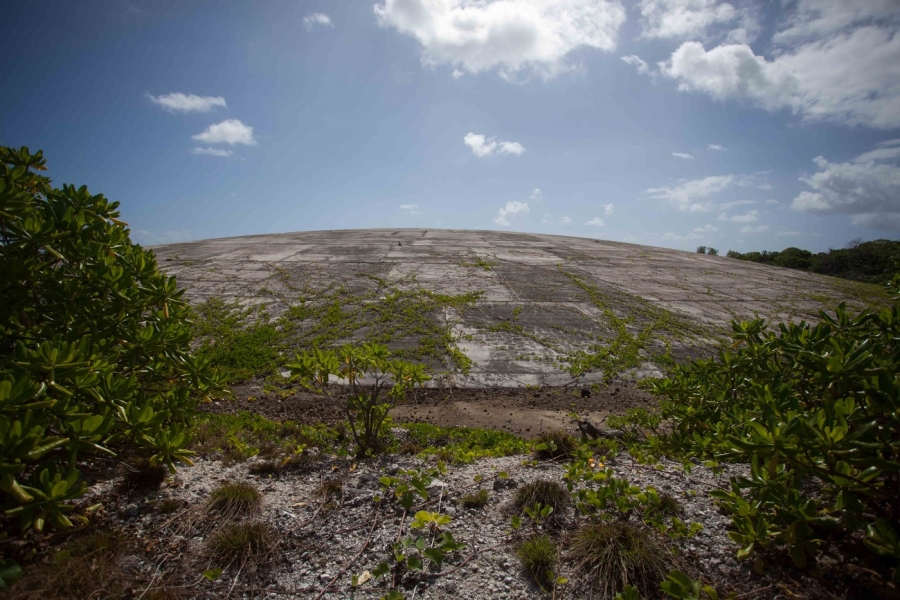
The Cactus device created a crater some 380 ft in diameter and 32 ft deep. Being well below sea level, the crater immediately filled with sea water. Teams of surveyors had looked at the structure of the crater, including a bottom layer of shattered, coral fallback from the blast itself. This was left in place. The fallback was believed to be more radioactive than the material that was to be placed on top of it. It was also believed that this sediment would help prevent the leaching out of radionuclides into the lagoon and the sea immediately offshore. Coral is so porous however that this assumption proved to be laughable. Since the crater was not constructed with any form of a preventative liner before being filled, sea water was free to enter – and exit – with little difficulty. This was a cost-saving measure. Eyewitnesses I have spoken to allude to the fact that the water level inside the crater rose and fell in lock-step with the tides.

A key wall, 2 ft thick, was constructed that ran the circumference of the crater, designed to stabilize the crater wall and to prevent the undercutting of the dome’s lower rim. Trucks were arriving constantly from the cement plant and disgorging their loads, which was pumped in from the crater rim and compacted into a dome shape by graders and heavy rollers. Ultimately 110,000 cubic yards of highly radioactive sand and dirt, enough to fill a football stadium, were compressed to fit under a huge 18″ thick concrete dome, comprised of 357 individually shaped trapezoidal panels, laid down in rows. 330,000 bags of cement were required for construction of the dome.
As Skip Weythman states ‘essentially the crater was not large enough to hold all the contamination from the 43 blasts so just the hottest soil scraped from the northern islands went in the crater, all the bunkers and steel from towers and miles of cables had to be cut and blasted into manageable size to be loaded on to the LARC and hauled out to the crane on the barge in the northwest center of the lagoon and placed into the unofficial Enewetak hydrological nuclear waste isolation site (the bottom of the lagoon) as the junk does not make for a good looking concrete.’
Make no mistake; Cactus is a problem of almost unimaginable proportions but it is a task that the United States needs to address immediately. To begin with, placing a huge pile of radioactive material on a coral atoll just a few feet above sea level is jaw-droppingly stupid. The dome was projected to last a thousand years but, at the time of its construction, very few people had even the vaguest inkling of global warming, melting ice caps and rising sea levels. That 1000-year figure looks hopelessly optimistic as the dome is already flaking and cracking now. Even if it was to last that long, its contents will still be plaguing us for at least another 23,000, so with all due respect, thanks for nothing. Despite the incredible amount of toil expended by the men who built it, the dome, as designed, wouldn’t pass muster as a domestic garbage dump on the US mainland, let alone a repository for the most toxic substances known to man.
Bulldozers and graders at work compressing the contents of the dome
In a supremely ironic footnote to history, Edward Teller, the self-proclaimed ‘father of the hydrogen bomb’ and principal designer of many of the weapons tested on Enewetak and Bikini, was among the very first to talk openly of the dangers that increasing levels of CO2 in the atmosphere posed for future generations. He had intuited some time before 1957 that the atmosphere would trap more heat from the Sun and begin to shrink the ice caps, and that coastal cities would eventually end up underwater. That year, Teller gave a keynote speech on the subject to a somewhat bemused audience at the American Chemical Society in Tulsa; they had been expecting a talk on the future uses of nuclear energy.
 The dome looks for all the world like a crashed flying saucer in the middle of the remote Pacific.
In hindsight, basing open-air nuclear testing on coral atolls is surpassingly stupid. To begin with, coral is tremendously porous, designed by Mother Nature to be that way, and easily shattered, easily lofted into the atmosphere when vaporized, yet it retains radiation extremely efficiently. So, Cactus is a vast repository for some of the deadliest contaminants on Earth, and it’s failing. We know that water enters and exits the crater almost at will. We know that stagnant water outside the dome is as radioactive as the actual contents and, perhaps most frighteningly, we know that local people have somehow gained entry to the inside of the dome, looking for metal to sell for scrap. The level of desperation needed to enter a radioactive vault just so that you can maybe put some food on the table can only be guessed at. That metal was found in the Far East, recognizable due to its unique radiological signature. If the contents enter the ocean no measure of clean-up will save the Pacific; the West coast of the US and South America will feel the effects as will Australia, New Zealand, and Indonesia.
Every couple of years the US government sends someone to survey the dome
This much is obvious. The contents of the dome need to be moved, somewhere well away from any rising seas. This ought to be less of a task than the original cleanup program; the material is already gathered in one place. It just needs to be put elsewhere. I say ‘just’ in full recognition that moving radioactive substances requires extreme care and special handling but then, I’m also reminded that the men who put this same material where it is now did so with no protective gear whatsoever! ‘Ought not to be that tough today. All it takes is the will. But therein lies the problem; if history is any indicator, then the US will have neither the will nor the inclination to clean up its own mess. Now-retired RMI foreign minister, Tony de Brum has become a fierce advocate for all island nations, attempting to draw attention to their plight. The Maldive Islands in the Indian Ocean are in a similar position. These islands will be gone all too quickly unless we find a way to drastically decrease the amount of CO2 in the atmosphere. And the idea that we have many years before the dome is entirely inundated can be quickly dispelled – king tides washed many houses into the sea just last year in Majuro, the capital. This could happen at almost any time now.
Now-retired RMI foreign minister, Tony de Brum has become a fierce advocate for all island nations, attempting to draw attention to their plight. The Maldive Islands in the Indian Ocean are in a similar position. These islands will be gone all too quickly unless we find a way to drastically decrease the amount of CO2 in the atmosphere. And the idea that we have many years before the dome is entirely inundated can be quickly dispelled – in 2015 king tides washed many houses into the sea in Majuro, the capital. This could happen at almost any time now.

The obvious fear is that the seas will rise to such an extent that the dome will be entirely inundated, that the contents, still full of incredibly deadly levels of radiation, will wash out into the Pacific; it’s a catastrophe in the making and nobody is doing a damn thing about it. We are not fear-mongering; the Marshalls are among the most threatened islands in the World and are already experiencing the direct effects of sea-level rise. The tidal surges like that in Majuro used to happen perhaps once a generation but now occur several times each year. These islands are dying. This is, in a nutshell, what this website is all about; it’s an alarm call. The aim is to raise awareness but also to get the United States to take ownership of the mammoth mess it left so cavalierly in its wake, trashing these beautiful island nations, destroying the Marshallese way of life and scattering the people to the four winds. You don’t walk away from a car wreck like this without looking back. Ownership is demanded. It’s expected from all civilized people on the planet. The US called the Marshallese people savages when they first arrived but I think it’s only too clear who the savage is in this equation. The treatment of these people has been nothing short of barbaric. This is the US’s mess; it needs to accept responsibility and do something about it.
 Picture taken in December 2008 shows a cemetery on the shoreline in Majuro Atoll, the RMI capital, being flooded from high tides and ocean surges.
Photo: Giff Johnson
It’s difficult to listen to the heartbreak of the Marshallese people at the decimation of their homelands. For centuries, they had lived an idyllic, peaceful lifestyle, in perfect harmony with the sea and the rhythms of nature. That was all shattered in 1946 when the US arrived to test different forces of nature within a weapon of unspeakable destruction. They know now that they can never return to their old way of life, contrary to all the promises made.